
Topo Map Scouting for coyotes
by Dave Affleck
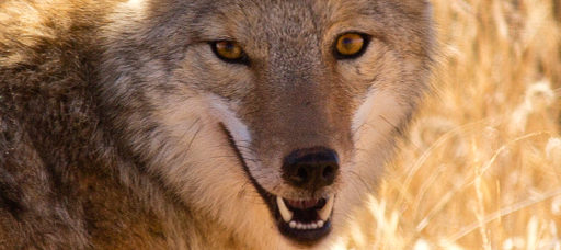
As a predator hunting video maker and a long time Foxpro Field Staff member, I get a lot of questions in email. These questions range from equipment and ballistics issues to fur handling. And… “The Question”, the one I get asked more than any other. “Where is a good place to go hunt coyotes?”
In the fall when deer season is over, I get email every day from my fellow Utah hunters asking me “where is a good place”. The standard response I give, is that I won’t tell them where I go, they need to get out and find a good place on their own. Because, the nature of hunting coyotes on public land in the West, is such that “where” you hunt, is by far the most important ingredient to success. But just exactly where I hunt, is constantly changing. Public land is just that – “public”. My good spots from one year, often aren’t so good the next year, for any number of reasons, not the least of which is other hunters finding and calling in the same places. It’s just the nature of the beast that I’m constantly searching out and exploring new areas. This is not a bad thing though! For one thing, we here in the West are blessed with virtually unlimited public land to roam at will. For another, I personally just love to get out and explore new areas. Truly, for me, having such a good excuse to get out and explore and become familiar with the lonely expanses is one of the most enjoyable aspects of coyote hunting.
Finding coyotes on a map – it takes practice!
So, we know we need to get out and do some exploring and scout new ground. But how do we choose a starting point? How do we make the most efficient use of our time and our gas money? Every successful public land predator hunter has his own answer to that question. For me, the answer lies in studying maps. Or, as I like to call it “Topo Scouting”.
I have enjoyed using topographical maps from an early age. As a teenager, I was lucky enough to land a summer job working as an assistant to an engineer for the Utah Division of Wildlife Resources. Part of my job was surveying DWR construction sites with my boss (mostly fish hatchery projects). I “ran rod”, holding the elevation rod while my boss used his old fashioned (even by 1970’s standards) transit and jotted down the coordinates by hand. Back at the office, he taught me how to plot the coordinates on paper by hand with a protractor, then “connect the dots” to draw an honest to goodness elevation contour line and create topo maps from scratch. Another task I was assigned that summer was to organize the pile of USGS topo maps the engineering department had. I had to go through a stack of Utah “quad sheet” topo maps taller than I was, one at a time, to catalog and organize them. I got to look at detailed topographic maps of the entire state of Utah that summer, as well as travel to many areas to help my boss make new maps. To say that my map reading skills were high by the end of that summer would be an understatement and it’s a skill I’ve continued to hone and use regularly ever since.
I tell you all this to illustrate that reading a topo map is a skill that takes experience and practice to really get the most out of. You may not see much value to it, or gain much useful information from map reading at first. But if you keep at it, you’ll find that the more you study maps of your hunting areas, the more useful information you’ll find yourself able to glean about new areas, simply by looking at a map. When you get really good at it, you’ll find that topo scouting is half science and half art. The science is easy to learn. The art takes a lot of experience to get good at.
Finding new coyote hunting spots – where to start?
So, by now, you may be wondering, just what am I looking for, when studying maps of a new area. The answer relates to another skill that comes only through experience. That skill, is learning to read terrain and how to choose and setup your stands. To a large degree, this comes down to personal preference. I have my own way of approaching the terrain and calling it, that I have worked out over the years. My terrain preferences and stand selection are based off of the way I like to hunt and the things I consider to be my strengths. Some of the factors that go into my terrain and stand selection preferences are that I hunt public land, I hunt during the day, I use a remote controlled Foxpro caller, that I am a competent rifleman but not a shot gunner, that I won’t walk very far to make a stand, that I do like to have my truck hidden from the stand, that I like to have some elevation above my caller and a good view and good shooting lanes a long ways out. These are just some of the factors that form my own personal preferences for the type of terrain I like to hunt, the kinds of stands I like to make and how I like to approach those stands. A shot gunner working the thick stuff, or a guy that hunts the river bottoms on private ranch land, will have very different terrain and stand selection preferences that work well for them. They’ll be looking for very different things on a map than what I am looking for. The point being, that you need to develop both skills, the ability to read terrain for coyote holding “structure” and how to best hunt that terrain to suit your own preferences, and the ability to read a topo map and recognize those terrain features you like and that coyote holding structure when you see them on a map.
Okay, so what am I looking for when I study a map? There are two basic types of information that you can see immediately. One type of information is the basic type of terrain. You can see if it is steep mountain, rolling hill or flat land, if there are creek beds or dry washes, if it’s timbered or clear etc. The finer points, like whether the flat area on the map is barren hard pan or a healthy sage covered flat, is something you’ll eventually be able to know, with experience and more familiarity with the larger general area. I look for the particular type of terrain, or “structure” as I call it, that best suits my hunting style. The second type of information that you can immediately see, is what type of road access there is. This is vitally important information! The best looking terrain in the world is no good to me if it doesn’t have the right kind of road access. Not all maps in all areas are going to be 100% accurate about what roads exist, but most will be pretty good. I like to utilize rough, two track 4×4 roads that see little use. Indeed, my “perfect” road access will require four wheel drive and be guaranteed to pin stripe the heck out of a full size pickup. Many experienced predator callers prefer better maintained, higher travel speed roads to cover more ground and make more stands in a day. With a little bit of experience it’s pretty easy to tell what kind of roads are there just by looking at the map. I like to drive on a rough two track to within a couple hundred yards of a stand, but have my truck hidden from the stand. Ideally, there will be a small hill that I can park behind and then walk around and sit down on to make a stand with elevation above my Foxpro and a good view all around. Ideally with more than one drainage or draw funneling into rifle range below me. I’m often able to pinpoint precisely this situation, on a map, in a place I’ve never been before. In other words, I not only identify a general area as looking favorable based on my map study, but I often pinpoint exact stand locations, down to where I’ll park the truck and where I’ll walk to and sit down. I’ve had these stands that I’ve picked out from a map pay off over and over again. Perhaps the most memorable, was one morning a couple years ago. I had topo scouted a new area and chosen half a dozen exact stand locations along a seldom used Jeep trail. My partner Tim and I called in four coyotes on the first stand, none on the second, six coyotes on the third stand and four coyotes again on the fourth stand. By 10am we had called in fourteen coyotes, in an area we had never been to before, using stand locations I had chosen ahead of time based on my map study. I’m telling you, once you get good at it, topo scouting works!
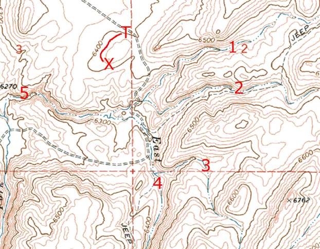
Topo “A” is an example of a single stand that I chose by topo scouting. I had never been in the area before. But on this stand, which I located precisely on the map and loaded onto my GPS ahead of time, we called in four coyotes and killed all four of them. Let’s talk about some of the things I saw on the map that attracted me to this spot. I parked the truck at the letter “T” on the map. Note that the road starts to go through a small saddle at that point and that the parking spot is well hidden from the stand. The red line is the approximate path that I walked from the truck, going around the back side of the small hill, never exposing myself to the area I’d be calling. The spot I sat down to call from is at the letter “X”. I set the caller about 40 yards in front and downhill from my sitting place. Now, note the red numbers 1,2,3,4 and 5 on the map. Those are five separate draws, or small drainages that all feed in to the area covered by my rifle on this stand. And draw #5 actually has two more draws feeding into it, that are within coyote hearing of the stand. So, what I saw on this map when topo scouting it from home, was that I had a bunch of draws all coming together, which is a terrain feature that has provided good stands for me many times in the past. And I also saw that I could hide the truck and only have to walk about 250 yards to get into position. I could even see from the map that I’d probably have good elevation above my caller and a good view on this stand. Last but not least, I knew this would make a better stand in the evening than in the morning due to the direction I’d be facing. Setups like this don’t always pan out of course, but frequently they do and this one certainly did!
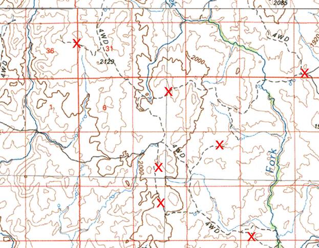
Now let’s look at another map (Topo B). This is a spot I have not been to yet. But I plan to hunt it someday. Some of the things that appeal to me, about this spot on the map, are: The roads marked as “4WD”. Nothing about topo scouting is 100%, but normally “4WD” indicates a rough two track that doesn’t see very much travel. Sometimes when I get there, I find these old trails are so faint, you almost have to know they are there to even find them. Which might mean, the coyotes living in this area don’t get as much pressure as those closer to more travelled roads. Also, note the river on the right side of the map. I have not been to this spot, but I’m somewhat familiar with the general area. It’s pretty dry country without much permanent water. The rivers that do exist are always what I call “life zones”. The bottoms along the rivers always hold good concentrations of prey for coyotes. And so usually, a decent population of coyotes will be found along these river systems. And finally, note how the terrain is broken up with lots of potential spots to hide the truck and get setup without walking very far. All of the red “X” marks are spots I think look good for being able to hide the truck and make a quick setup, calling into country that I expect to hold coyotes. Note, I wouldn’t expect all those “X” marks to work out as actual stands, but seeing so many potential spots in one area on the map is always a good sign. The terrain doesn’t look too steep, either. To me, it looks “just right” – enough small hills to make hiding the truck and sneaking into position easy, but not so steep and deep as to make it hard to move around in. Once more though, I need to stress that these are all characteristics that “I” like to see, to go along with my personal preferences in how I hunt coyotes. What you need to be looking for, are the things that go along with your personal hunting preferences. Whether that be terrain type, road access, cover, whatever it is you like to see, that’s what you need to be looking for when you’re topo scouting.
Topo scouting for coyotes – wrap up
Now, make no mistake, studying maps is no replacement for actually going out and exploring, getting your eyeballs on the terrain and your boots on the ground. But studying maps can be a huge asset in making the most efficient use of the time, effort and gas money you put into exploring new ground. At the most basic level, even if your interest or skill level never reaches the point of actually pin pointing stand locations on the map, there is still a lot of value in simply being able to eliminate large areas from consideration based on your terrain and road access preferences.
As we’ve already discussed, when I start looking at maps of a new area, the first thing I look for is the type of terrain and road access that I prefer. Once I’ve decided that a general area looks interesting, the next thing I look for are travel/calling routes through the area. I look for the kind of primitive roads I like. I look for routes that will take me right into the terrain I want to call. I look for routes that provide plenty of terrain features for hiding the truck. I take into consideration the time of day and direction of travel that will work best in certain areas to have the sun or prevailing winds in my favor. I look at all of these things and more, trying to plan a fairly exact route that I can follow for a whole day of hunting. Often, route planning is as far as I go with my topo scouting. Leaving precise stand selection to be played by ear once I’m actually there. But sometimes I do go so far as to plan out precise stand locations entirely by topo scouting.
A whole article could easily be devoted to the tools of topo scouting and navigation – mapping software and GPS. But I’m just going to touch briefly on the technology aspects of topo scouting here. I do all my topo scouting on the computer. I always have paper maps with me in the field, but for topo scouting, paper maps can’t even begin to match the usefulness of computerized maps. The maps that I prefer, are the official USGS topographical maps. I have every single USGS topo for Utah and all the surrounding states on my computer. Both the very detailed 7.5 minute maps (“quad sheets”) and the less detailed but much larger area 1:100,000 series metric maps are included with the program I use. The program allows you to switch instantly from the 7.5 minute maps to the 1:100,000 maps or even a Google Earth view of the area. For some areas there are even aerial photos.
A word about Google Earth… It seems to be a fairly popular tool for hunt planning. And I’ve used it, a lot, myself. But, for me, for the areas I hunt, my opinion, it’s not anywhere near as useful as the USGS maps are. Not even close. I always look at Google Earth when topo scouting and do occasionally get some value from it. But, for the most part, for my purposes, it’s just not that useful compared to the maps.
It should go without saying, that I use a GPS in the field. The mapping program and my topo scouting go together with GPS like powder goes with lead. The GPS in conjunction with good mapping software makes navigating new places really just too easy. Just as important as the ease of navigating new areas though, is the database of information about my own hunts that the GPS gives me. I always input all the GPS data back into the mapping software when I get home. A “bread crumb” track of every move. And every stand where coyotes are killed marked. Over quite a few years of doing this, I now have permanently mapped all of the travel routes that have worked well for me. As well as the patterns of good stands marked. Whenever I topo scout, all this accumulated data is overlaid on the maps. This data, stored permanently and not relying on my own faulty memory, are an invaluable tool for me. My partner Tim and I like to joke about how much I could sell my GPS unit for, with all of my public land stands marked on it – stands that have produced hundreds of dead coyotes.
At the end of the day, what topo scouting is really all about, is just getting out and trying new country on for size. Western public land hunters are blessed with the freedom to go out and explore new places seemingly almost without end. And for me, the journey, the just getting out there to see what I can see, is as much fun as the hunting itself. I just love getting out and exploring! Topo scouting just helps me do it more efficiently. I hope some of this information helps you to get out and enjoy some exploring of your own.
– Dave Affleck
Very well written and helpful article! Thanks for taking the time to do this.
Thanks for taking the time to read it and let me know you liked it Bret!
Dave, were you “DAA” on huntmastersbbs? If so, I think the dudes there refer to you as “porn-stache”
I knew a Dave Affleck , any relation, he would be in his 70,s good article. I hunt I little differently, thanks